Long-range mission planning is vital to Naval operations and often performed months in advance. Knowing the environment where ships, aircraft, Sailors and Marines will be operating is crucial information. Historically, planners have had to rely only on climatological conditions, but climatology only provides the average conditions of the environment and can be far different from reality. NRL is creating long-range environmental prediction systems, which are currently accurate only in the short term.
In the environments the Navy and Marine Corps operate, Sailors and Marines also have to navigate in the ocean, deal with waves, and in the era of a “Great Power Competition,” grow their ability to work in and around sea ice.

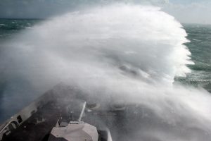
Waves crash over the bow of the amphibious transport dock ship USS San Antonio (LPD 17) as the ship speeds to the last known location of a missing fishing vessel off the North Carolina coast in 2007. The ship braved 14-foot waves during the search for the craft, which reported losing electronic and navigation capabilities. The craft returned to port using a magnetic compass. (U.S. Navy photo by Mass Communication Specialist 1st Class Erik N. Hoffman)
This need to know what to expect in the total environment is why researchers at the U.S. Naval Research Laboratory are working on extending the limits of environmental prediction by developing a globally-coupled model called the Earth System Prediction Capability, or ESPC.
“ESPC is probably the biggest project I’ve worked on,” said Carolyn Reynolds, PhD, a meteorologist at NRL’s Marine Meteorology Division in Monterey, California. “It’s the longest project. It could be the project with the most impact. I’m very excited.”
Reynolds coordinates her division’s work on the atmospheric component of the ESPC.
“It’s exciting because it’s a new opportunity for us, as the Navy has never had atmospheric forecasts beyond 16 days or ocean forecasts beyond 7 days. Now we’re going to have forecasts to 45 days,” Reynolds said. “We’re not the first to couple models, but what makes us unique is that we have a very high horizontal resolution in the ocean and sea ice components of the system.”
NRL scientists have been working on this project for more than four years now, and the effort relies on the expertise of researchers from a variety of disciplines: ocean modelers, atmospheric modelers, sea ice modelers, wave modelers, data assimilation experts and computer scientists.
In Monterey, NRL’s meteorologists contribute the atmospheric component for ESPC, while at Stennis Space Center in Mississippi, NRL’s Ocean Sciences Division provides the ocean, sea ice, and wave components.
NRL already has models for each of ESPC’s individual components, and pieces of ESPC are already in use.
For example, the U.S. National Ice Center (NIC) is already using pre-operational 45-day sea ice forecasts from ESPC to support Arctic and Antarctic exercises and resupply missions.
“It’s the coupling of the individual components that creates the interdependency of ESPC,” said Joe Metzger, oceanography lead at Stennis Space Center. “We’re working hard to stitch them all together and then shepherd them through the transition process from research and development to operations at the Navy’s Fleet Numerical Meteorology and Oceanography Center.”
Pulling the pieces together
Historically, meteorologists and oceanographers designed and employed discrete models of Earth systems to produce individual forecasts: ocean models to predict the ocean circulation; atmospheric models for the weather; sea ice models to predict the cryosphere; and wave models for the ocean surface.
Researchers knew the Earth’s environmental conditions were linked even though the models were seldom interdependent.
“We’ve realized for some time that these processes are all coupled,” said James Doyle, PhD, a senior scientist with Marine Meteorology Division. “The atmosphere is exchanging information with the ocean in terms of temperature and moisture, and even the currents can affect the winds in the low levels to some degree.”
Metzger said wind stress and heat exchanges at the ocean surface can impact ocean currents, waves, the sea ice cover as well as the entire ocean thermal structure.
“Things like El Niño, for example – they’re inherently coupled phenomena. They come about because of the way the ocean and the atmosphere talk to each other,” Reynolds said. “We’re coupling all these systems together with the hope—and I think we have evidence that it’s working — that we’ll be able to capture some of these coupled phenomena that have predictability on longer time ranges.”

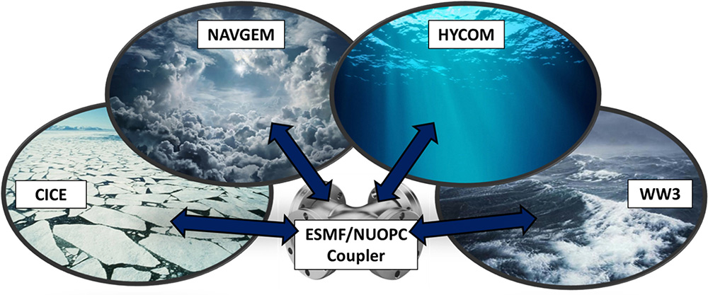
The various model components that make up the Earth System Prediction Capability (ESPC): The NAVy Global Environmental Model (NAVGEM) for the atmosphere, the HYbrid Coordinate Ocean Model (HYCOM) for the ocean, the Community Ice CodE (CICE) for the cryosphere, and WAVEWATCH III® (WW3) for waves. The individual models exchange information with each other via a coupling layer using tools from the Earth System Modeling Framework (ESMF) and the National Unified Operational Prediction Capability (NUOPC).
Four years? Why is it taking so long?
Each model has its own grid of the Earth, a massive set of data points. Imagine the latitude and longitude lines crisscrossing a globe. Each intersection of the lines marks a grid point where the model equations are solved over and over again from the top of the atmosphere to the bottom of the ocean.
Each model’s grid is different, and the grids inside individual models can also vary.
For example, the distance between grid points for HYCOM, the ocean model, is only about four kilometers near the Equator, but this narrows to less than two kilometers near the North Pole. Imagine a grid spanning the entire Earth with points less than four kilometers apart — that’s an exceptionally large number of grid points and makes ESPC computationally expensive to run.
To enable the models to interact with each other, NRL scientists work with scientists from the National Oceanic and Atmospheric Administration, NASA, universities and research laboratories to develop the Earth System Modeling Framework. It’s essentially a coupler to allow the different model grids to exchange information.
And though the models themselves work well on their own, they don’t necessarily work well when they start talking to each other. They have to cooperate. So much of their work in model development involves adjusting the models themselves.
“It’s a relatively easy engineering problem to wire the models together, but the real science comes in the research to make sure the physics of each model have the proper feedbacks when exchanging information,” said Metzger.
“It took us quite a bit of time to get our models improved — at least for the atmospheric model,” Reynolds said. “We spent a lot of time modifying the model so that it would behave well in a coupled system.”
Four years into system development is atypical, Reynolds said. From conception to deployment, it can take on the order of 10 years or so to construct these systems. It’s taking less time to develop ESPC because they’re building the coupled system from preexisting component systems.
After the ESPC debuts, researchers will continue refining and improving the system. The system’s final operating capability is scheduled for fiscal year 2022.
Observations Sidebar
The observational data driving ESPC is the same data used by the existing operational stand-alone forecast systems.
Every day, environmental observations come from weather balloons launched twice a day all over the Earth, surface weather stations, ocean buoys, ships, aircraft, and even from sensors attached to marine mammals.
Additionally, millions of observational data points come from satellites, providing temperature, moisture levels, and winds in the atmosphere, sea surface height, sea surface temperature and sea ice concentration.
All of these observations are fed into creating the initial states of the models that comprise the Earth System.
The initial states are critical in a model because researchers never know with perfect accuracy the initial state of the atmosphere, ocean or cryosphere — the conditions from which a coupled Earth system starts. Over time, small errors in the initial state will propagate, grow and degrade the forecast.
Forecasts also become less accurate the longer researchers extend them in time and the upper limits of skillful predictability are different for the atmosphere, ocean and sea ice.


