Off the north coast of Alaska in the Beaufort Sea, the Sun will not appear until roughly nine a.m., its edge arcing over the horizon, where a spill of puffy clouds briefly hides its emerging face.
It’s the beginning of October. A sheet of ice already covers the sea’s surface. Its marble-white hue reflects dawn’s vibrant colors as the ice whines and moans under the push of currents and squalls.
Floating still among the ice is the blue hull of a ship—the RV Sikuliaq, a 261-foot (80-meter) ice-capable vessel owned by the National Science Foundation.
Zach Burchfield, an electrical engineer with the Johns Hopkins Applied Physics Laboratory (APL) aboard the vessel, says temperatures outside drop as low as minus 15 F (minus 26 C). With gale-force winds blowing at 45 miles per hour (72 kilometers per hour), however, it feels more like minus 50 F (minus 45 C).
Born and raised in Louisiana, Burchfield had never dreamed of going to the Arctic. He knew heat and humidity well, but having never been north of Maryland, the Arctic was a different planet. “It’s like something out of ‘Interstellar,’” he said, referencing the popular science fiction film. “It’s like you’re in a frozen desert, where ice seems to stretch out forever.”
Having now completed his third trip to the Beaufort Sea in August 2023, Burchfield has become well acquainted with the Arctic and the cold. He studies how radio waves propagate through the Arctic’s frigid environment, working as an engineer and researcher with the Office of Naval Research’s Arctic Mobile Observing System program. It’s an innovative naval prototype project to develop a persistent yet mobile two-way communications network of autonomous buoys, sea gliders and other technology in the Arctic.

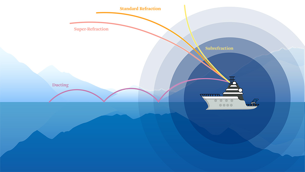
Radio waves used in radar and radio systems can travel in various ways, depending in part on the atmospheric conditions. Under standard conditions, the waves will follow a standard refraction that’s 4/3 of Earth’s curvature, but changes in temperature, pressure and humidity bend the signals upward or downward. Wave ducts, which form when warm dry air sits on top of cool moist air, can allow signals to travel hundreds or even thousands of miles.
Radio waves are fundamental to these and other communications systems, as well as to any navigational and radar systems used by ships and aircraft.
Burchfield focuses on radio frequencies above 100 megahertz used in radio and radar systems, and how they broadcast depends partly on the environment — atmospheric pressure, temperature, how much water is in the air. Under standard atmospheric conditions, radio waves will bend just slightly more than the rate of Earth’s curvature before going off into space. In other conditions, these waves may subrefract, bending upward toward space and dramatically cutting the distance radio signals travel.
Occasionally, warm dry air floating above cool moist air creates a surface duct, a phenomenon that, similar to a waveguide, refracts radio waves so they propagate for hundreds or even thousands of miles. The warmer the climate and the greater the change of moist air with altitude, the larger the duct and the farther waves propagate. Surface ducting is common in places where warm dry air blows from the shore over cool moist air on top of the sea, such as the Persian Gulf, the Red Sea and Southern California.

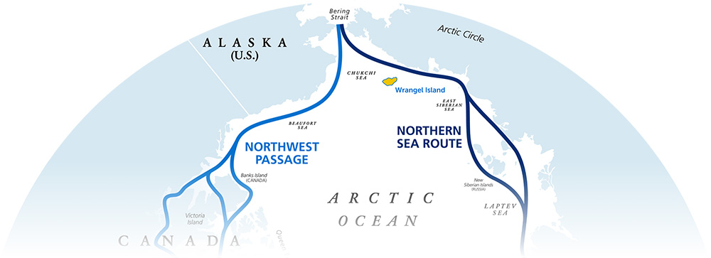
The Northwest Passage and the Northern Sea Route — two thawing maritime trade routes along the north coasts of North America and Asia, respectively — converge at the Bering Sea. Russia has claimed exclusive rights to patrol and develop along the Northern Sea Route, including upgrades to its military facilities on Wrangel Island (in yellow), roughly 300 miles from Alaska.
It’s trickier in the Arctic.
Burchfield has used an assortment of equipment to collect atmospheric data: weather balloons, weather stations, transponders, various antennas, and even a custom-made uncrewed aeronautic vehicle built at APL called the meteorological unmanned air system (Met UAS). His measurements extend up to 3,000 feet (914 meters) above the sea surface, and what he and others have found is that ducting in the Arctic rarely happens.
That’s not too surprising, Burchfield said. As a cold desert, the Arctic’s frigid temperatures and low humidity mean ducting ought to be rare. But the times when one does form, it can do so with stunning effect. While in the Arctic in October 2018, Burchfield’s co-worker Dave Drzewiecki reported hearing radio signals from an aircraft more than 550 miles (885 kilometers) away. “The typical horizon for aircraft is around 300 miles [483 kilometers],” Burchfield said, an indication of a substantial surface duct.
That inconsistency is a problem.
Temperatures in the Arctic have climbed four times faster than the global average, rapidly melting ice. From 1979 to the present, the region’s maximum sea ice extent every March has steadily declined by 2.5% per decade, according to the National Snow and Ice Data Center. Between the years 2050 and 2060, researchers agree that the ice will have subsided enough that commercial shipping lanes through the Arctic will become accessible and navigable. With more people entering Arctic waters, there’s a need to have reliable communications capabilities to help ships safely navigate the region, ensure responders can quickly react to emergencies, and safeguard the U.S. military’s ability to protect the border.
Even during the summer when warmer temperatures infuse more moisture into the air so ducts ought to form, models suggest up to 50% of radio waves in the Arctic will subrefract, bending them up toward space and reducing the range of the system. Compounding the issue is that scientists aren’t certain how radar propagates over ice. In fact, Burchfield said, he doesn’t know if evaporation duct models even hold for conditions over ice.
“There aren’t enough data yet to make accurate predictions in the Arctic.” he said. “Between limited seasonal access and the harshness of the environment, you’re very restricted in forecasting and prediction.”
Communications is one of the top challenges in the Arctic right now, according to Cameron Carlson, the assistant director at the University of Alaska Fairbanks’ Center for Arctic Security and Resilience. “We have communications systems that are super-information intense, but when you put those in the Arctic, they don’t work,” he said. But it’s just one obstacle among many. “Everything is different in the Arctic, even the way you have to carry batteries.”
More than 100 APL scientists and engineers have recognized the impending challenges and long-term implications of a melting Arctic, from technology and national security issues to environmental and conservation concerns.
In response, this community of pole-focused researchers at the Lab, in collaboration with organizations across the country, has organized to build the knowledge and equipment that will enable the nation to have a sustainable and environmentally conscious presence in the region.
Relative to other Arctic nations, the U.S. has had minimal residence in and around the Arctic, giving those nations a leg up for which the country is now trying to compensate.
The most notable among those nations is Russia. Since 2007, when the Russian Federation planted a titanium flag on the North Pole seabed to stake a symbolic claim to the region’s economic bounty, the country has increasingly focused on the region. It has reopened at least 50 Soviet-era military outposts in the Arctic. It has laid plans to control emerging sea routes that would shuttle traffic through the Bering Sea between Alaska and Russia. It’s investing in radar stations, search and rescue, and the refurbishment of dozens of military posts, including on Wrangel Island, some 300 miles (480 kilometers) from the west coast of Alaska. Recent satellite observations and aviation data from Novaya Zemlya in the Russian Arctic suggest the country tested an experimental nuclear-powered cruise missile in the region: a Burevestnik or SSC-X-9 Skyfall — a weapon theoretically capable of flying 14,000 miles (22,530 kilometers).
Lauren Ice, an analyst in APL’s National Security Analysis Department, led a study to explore future operational scenarios that the U.S. could expect to conduct in the Arctic. She says the road to catch up is steep.
As an anecdotal example, she pointed to August 2020, when U.S. fishing vessels working in U.S. waters in the Bering Sea were startled to spot Russian warships on the horizon and aircraft barking at them over intercoms to vacate the area. Unbeknownst to the fishers, the Russian navy was running a military exercise, Ocean Shield, in the region. Dumbfounded, ship captains called the U.S. Coast Guard, which from so far away could do nothing more than tell them to follow the Russians’ orders.
“It’s not an area where we have a large, sustained presence. During the 2020 incident, there were no Coast Guard or Navy ships in the area that could respond.” Ice explained. “We need to increase our ability to respond to such incidents, but there are a lot of questions about how to do so, including if and where we should build more infrastructure in the Arctic, based on stability, location and handling the extremes of the environment.”
What would it take for the U.S. in the future to respond to such a scenario? How can we improve our technology and build infrastructure so we can operate and survive?
“That’s what we’re trying to help solve,” Ice said.


